Telf. 0034 638 118 780 [email protected]
Puerto Deportivo Marina de Formentera - La Savina Formentera (Islas Baleares)
Rental and booking of boats in Formentera. Enter the dates to check availability and offers
Formentera
Formentera is the smallest inhabited island of the Balearic Islands (Spain). It is located to the south of the island of Ibiza just 2 nautical miles from it (about 3 kilometers), although the distance between the ports of Ibiza and La Savina (Formentera) is 12 miles (19.3 km).

Despite being a small island (83.2Km2), its cut-out shape means that it has a large stretch of coastline (69 km) in proportion to its surface, with many beaches, numerous coves and solitary places to get lost. The island is small, but accessible and comfortable. We can cross it for the most part by bicycle, along the green paths, pine and juniper forests and its rural interior. For longer journeys we can use a car or a motorbike.
The island of Formentera stands out for its great environmental beauty and for its still wild landscape of dunes and beaches, which are preserved in excellent condition. As soon as we disembark in Formentera we will breathe that air of characteristic calm and immediately we will be captivated by its waters, unique for their transparency and turquoise color that evokes tropical latitudes.
Beaches of Formentera
Formentera is known and valued touristically for its beaches of transparent waters and fine white sand that mute the visitor with its turquoise tones. These are protected beaches and little altered by man, but located in a territory equipped with modern tourist infrastructures of a family nature.
Observing the peculiar contour of Formentera, three large stretches of beaches are established: on the northeast side the Llevant and Tramuntana coasts, on the opposite side, the north-western coast with the most famous beaches of the island, Illetes and Cavall d’en Borràs , to the south the coast of Migjorn.
The peninsula of Es Trucadors, to the north of the island, is a long tongue of sand that narrows from south to north. The beaches of Llevant, Ses Illetes and Es Cavall d’en Borràs occupy the west face. Illetes is the most famous beach on the island and the most visited by tourists. Although in the central hours of the day it registers great concentration, walking beyond the last authorized parking area you can find stretches almost deserted, even in high season.
In addition, the nearby Llevant beach is much less crowded than Illetes. It occupies the entire east face (to the east) of the beach and is also fine white sand although with small rocky surfaces. Advancing towards the north, these two beaches are so few meters away that you can extend the towel in between and contemplate both at the same time.
All this territory is within the Natural Park of Ses Salines d’Eivissa and Formentera, an area of great environmental protection. Those who visit it by motorcycle or car, have to pay a fee at the entrance of the Park, those who access it on foot, by bicycle or electric vehicle do so for free.
In the natural continuation of Es Trucadors, we find S’Espalmador, a private island but of public enjoyment. It is very easy to walk on foot and has several beaches, the most visited beach is that of de S’Alga, on its west coast. To access S’Espalmador (it is forbidden to cross swim due to sea currents) is done through a local company that makes several trips daily, departing from Puerto de la Savina and stopping at Illetes beach. Other options are to hire a nautical excursion or rent a boat.
The other great beach of the island is the beach of Migjorn. Its 5 km crescent-shaped extension covers the entire south of the island from the Es Mal Pas area to the Es Copinar area. The beach of Migjorn has sectors with their own place names that differentiate one area from others, from west to east: Es Mal Pas, Es Ca Marí, Racó Fondo, Còdol Foradat, Es Valencians, Es Arenals and Es Copinar.
Es Caló des Mort deserves special mention. a small cove after the beach of Migjorn separated from the area of Es Copinar by a rocky and steep area.
On the west coast of the island cliffs predominate, among which appears a small natural bay of great scenic beauty and transparent waters. It is the beach of Cala Saona, very appreciated by families, as its clear waters are shallow. In addition, it is framed by small cliffs and a large number of dry docks in good condition.
The Tramuntana coast occupies the north central part of the island and is a type of low rocky coast. It is gratifying to walk, starting at the Racó de sa Pujada, and among the numerous rocky stretches it is relatively easy to find nooks and crannies. It is one of the quietest places, even in high season. The only coastal town in this area, Es Caló de Sant Agustí, is highly esteemed by residents and visitors, by its fishing port and its qualified gastronomic establishments. Just a 2-minute walk away are Ses Platgetes, two small contiguous coves in which the sand alternates with rocky surfaces.
At the westernmost end of this coast is Cala en Baster, a rocky cove surrounded by high limestone walls in which the boat berths made in natural caves stand out. To access it easily you have to do it from the town of Sant Ferran.
In Formentera there are 2 beaches adapted for people with reduced mobility: Es Pujols and Arenals. Both have access ramps, a shaded platform, handrails, amphibious chairs and lifeguards. Arenals has adapted bathrooms and reserved parking.
Practical advice and detailed information in the Beach Catalog
Charming corners
Formentera is known for its beaches and transparent waters, but if we visit its interior we will find small towns, lighthouses, towers and mills, lakes and salt pans, caves and hidden caves, and beautiful forests of junipers and pines that alternate with dunes and rocks of shapes capricious.
ES CALÓ DE SANT AGUSTÍ
Small population of fishing tradition with a peculiar natural harbor and traditional restaurants. Its wooden boathouses, whose function is to protect small boats from salt water, were declared a place of cultural interest in 2002. The walk around is full of contrasts: the small sandy coves of Ses Platgetes to the west and the cliffs of the Mola to the east. Nearby is the starting point of the green route 25, which runs through the historic path to climb up to La Mola, known as the Camí de Sa Pujada. As we ascend we will be surprised by the best views of the island, the Racó de Sa Pujada and the Pou des Verro.
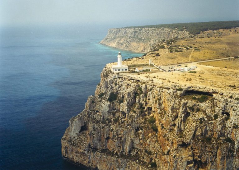
FARO DE LA MOLA
On the east end of the island, it is considered by many visitors as a magical place, like a beacon of the end of the world. Next to the lighthouse is a monolith in honor of the writer Jules Verne for the mention he makes in his book “Hector Servadac (travel and adventures through the solar world).” The most direct way to get to the lighthouse from Pilar de La Mola without stepping on the road is to do it via greenway 29. This route is also a passport to travel in time a hundred years ago, due to the rustic character of its rural landscape , the presence of cattle and the pleasant surprise of finding a house to the left of the road cataloged as architectural heritage, for its typical features perfectly preserved. A formidable panoramic from the cliffs of La Mola will put the final icing on this unforgettable ride.
FARO DEL CAP DE BARBARIA
The image of an almost desert landscape, a narrow road, the distant lighthouse in the center and the blue of the sea in the background, is part of the collective cinematographic imaginary. The protagonist lighthouse of this photograph captured by Julio Medem in the movie “Lucía y el sexo” is that of Es Cap de Barbaria, located in the southwestern corner of the island. Es Cap de Barbaria is the rocky elevation located to the south of the island and is also a place where sensations of immense solitude and freedom come together. It is a meeting place for the sunsets for the wonderful views of the magical islet Es Vedrá. A short distance from the lighthouse is an eighteenth-century watchtower, Torre des Garroveret, which once protected the island from invaders. The green routes 8, 10 and 11 will lead us here, also passing through the prehistoric sites of Cap de Barbaria.
ESTANY DES PEIX
It is a small lagoon with a narrow opening to the sea that allows the entry of small boats for anchoring. This small lake is an ideal setting for the practice and learning of water sports with small draft vessels: windsurfing, kayaking, sailing … In addition, it has small shallow beaches, which together with its warm temperature exceeds that of the sea, make it an ideal destination to spend an afternoon at the beach with children.
ESTANY PUDENT Y SES SALINES
The Estany Pudent is the great lake that is located to the north of the island, between the towns of La Savina and Es Pujols, and it is forbidden to swim. It is a highly recommended place to walk on foot or by bicycle, both for its scenic value and its importance for the sighting of the many birds. The Camì D’es Brolls borders a large part of the lake and, as the name suggests, contains underground “fountains” of fresh water, making possible an ideal vegetation for birds to nest. In winter it is common to observe flamingos, as well as herons and mallards. In this peculiar environment, reeds, reeds and other freshwater flora coexist with vegetation adapted to the saline environment creating authentic marshes. Very close we find Ses Salines, characteristics for the pink and violet tonalities that they present, especially in summer. They are cultural heritage of Formentera and were the only industry of the island in the pre-tourist era.
CAN MARROIG Y PUNTA DE SA PEDRERA
Visiting the eastern coast, between the port of Savina and Cala Saona, we find a steep coast formed by a desert of rocks of strange and curious shapes, which is known as Sa Pedrera and was once a quarry. Visiting this coast from the sea with a boat will allow us to enjoy the enormous marine wealth that is found in it. It is recommended to practice snorkeling because of its shallowness in the proximity of the coast and it is usual to see the diving excursions for the beauty of its seabed with a great presence of Posidonia. They complete this varied landscape, the next wooded area in which the Can Marroig estate is located. Here we can enjoy the shade of its pines and junipers or take a short break taking advantage of its facilities prepared for a family picnic. In addition, this space offers visitors information and educational activities related to the protected natural environment.
More tours and places with charm in the Map and the Green Routes Catalog
Info formentera.es
HELIX RENT A BOAT FORMENTERA
Puerto Deportivo Marina de Formentera, local 6, La Savina - Formentera (Islas Baleares)
Lat. 38º 44′ 2″ N / Long. 1º 24′ 55″ E
Telf. 0034 638 11 87 80
[email protected]

Helix Rent a Boat Formentera © 2021
Legal Warning / Privacy Policy / Terms and Conditions / Cancellation Policy